Wednesday, October 11, 2017

Thursday & Friday Oct 12 & 13th Days 36 & 37

Assignments due Thursday/Friday 


Long/Lat/seasons Presentation
Long/Lat/Seasons Presentation

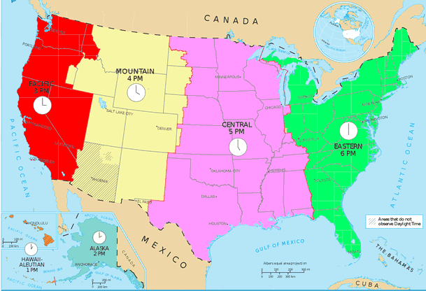
TimeZone Project

Directions Sheet

Time Zone Form

Assignments due NEXT week Tuesday/Wednesday
Early Map Making Article Summary and Questions- Early Mapmaking Article
Student Form to be used on the article


Explorers Project should be ready to display Tuesday/Wednesday at the end of the Block

Modern Map Making Article Questions - Here is the Article and questions
Future of  Map Making Article Questions - Here is the Article and questions

Mapping and Explorers

Objective(s):
1. The advantages of coordinating multiple geographic representations—such as maps, globes, graphs, diagrams, aerial and other photographs, remotely sensed images, and geographic visualizations to answer geographic questions
Therefore, the student is able to:
A. Explain the advantages of using multiple geographic representations to answer geographic questions, as exemplified by being able to
Explain how multiple geographic representations and geospatial technologies (e.g., GIS, GPS, RS, and geographic visualization) could be used to solve geographic problems (e.g., help determine where to locate a new playground, or identify dangerous street intersections within a community).
Describe how an analysis of urbanization can be done using differ­ent geospatial technologies (e.g., RS for land use, GIS data layers to predict areas of high/low growth, GPS and GIS for identifying trans­portation issues regarding growth).
Explain how multiple geospatial technologies can be used to solve land-use problems (e.g., effects of new farming technologies on the sustainable production of food, preservation of wetlands in bird mi­gration flyways).

Rationale: Understanding how maps were created and used allows students to understand the history of exploration and its impact on imperialism.

Evidence: Being able to articulate who pioneered/paid for the trips of explorers will allow students to list and explain the historical significance of maps.
________________________________________________________________________________


History of Map Making presentation
Presentation  - you will have access to a pdf copy of this presentation when it has been presented

 ________________________________________________________________________________

EXPLORERS PROJECT


 When learning about early Map Making, it should transition into how were those maps used and or expanded into the maps we know today. For that, we will study early explorers to understand why they ventured out to "discover" new lands and how maps were shaped by these voyages.

An explorer will be assigned to each student.The Explorer you are assigned is the explorer with the same number as your current seat.
i.e student sitting at seat 11 gets explorer #11
The directions for the project are listed below

This is the World Map you will use on your Explorers project -  ( here )
This map is very big, and you should crop out the part of the Map where your Explorer took his voyage(s). Use Google Slides to draw the path(s) from where your Explorer started and where he landed. Be sure to use dates and different colors to depict different voyages (if he in fact took more than one voyage)


Explorers Project - Directions Page: ( Link )


Resources for the Project

Explorers Name and links to informational websites: ( Link )
Explorers Information website:( Link )  
All about Explorers:( Link )
Notable Explorers: ( Link )
Conquistadors: ( Link )
Mr Donn's Site: (Link)


When you finish with your Explorer Project submit it into Google Classroom Folder.
Then Start
___________________________________________________________________________________


Modern Map Making Article - ( here )
Future Map Making Article - ( here )


Tuesday, October 10, 2017

Tuesday & Wednesday Oct 10th and 11th Days 34 & 35

Assignments due Thursday/Friday

Assignments due NEXT week Tuesday/Wednesday

Early Map Making Article Summary and Questions- Early Mapmaking Article
\
Explorers Project should be ready to display Monday/Tuesday

Modern Map Making Article Questions - Here is the Article and questions
Future of  Map Making Article Questions - Here is the Article and questions

Mapping and Explorers


Objective(s):
1. The advantages of coordinating multiple geographic representations—such as maps, globes, graphs, diagrams, aerial and other photographs, remotely sensed images, and geographic visualizations to answer geographic questions
Therefore, the student is able to:
A. Explain the advantages of using multiple geographic representations to answer geographic questions, as exemplified by being able to
  • Explain how multiple geographic representations and geospatial technologies (e.g., GIS, GPS, RS, and geographic visualization) could be used to solve geographic problems (e.g., help determine where to locate a new playground, or identify dangerous street intersections within a community).
  • Describe how an analysis of urbanization can be done using differ­ent geospatial technologies (e.g., RS for land use, GIS data layers to predict areas of high/low growth, GPS and GIS for identifying trans­portation issues regarding growth).
  • Explain how multiple geospatial technologies can be used to solve land-use problems (e.g., effects of new farming technologies on the sustainable production of food, preservation of wetlands in bird mi­gration flyways).
Rationale: Understanding how maps were created and used allows students to understand the history of exploration and its impact on imperialism.


Evidence: Being able to articulate who pioneered/paid for the trips of explorers will allow students to list and explain the historical significance of maps.
________________________________________________________________________________


History of Map Making presentation

Presentation  - you will have access to a pdf copy of this presentation when it has been presented


________________________________________________________________________________
EXPLORERS PROJECT


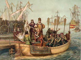
When learning about early Map Making, it should transition into how were those maps used and or expanded into the maps we know today. For that, we will study early explorers to understand why they ventured out to "discover" new lands and how maps were shaped by these voyages.


An explorer will be assigned to each student.The Explorer you are assigned is the explorer with the same number as your current seat.
i.e student sitting at seat 11 gets explorer #11
The directions for the project are listed below


This is the World Map you will use on your Explorers project - ( here )
This map is very big, and you should crop out the part of the Map where your Explorer took his voyage(s). Use Google Slides to draw the path(s) from where your Explorer started and where he landed. Be sure to use dates and different colors to depict different voyages (if he in fact took more than one voyage)


Explorers Project - Directions Page: ( Link )

Resources for the Project
Explorers Name and links to informational websites: ( Link )
Explorers Information website:( Link )  
All about Explorers:( Link )
Notable Explorers: ( Link )
Conquistadors: ( Link )
Mr Donn's Site: (Link)


When you finish with your Explorer Project submit it into Google Classroom Folder.
Then Start
___________________________________________________________________________________
Modern Map Making Article - ( here )
Future Map Making Article - ( here )

_____________________________________________

Monday, October 9, 2017

Monday Oct 9th Day 33

Mapping Monday's & Current Events

Today we will get our textbooks and go over the process of Current Events and Mapping assignments

Objective: Given access to a Chromebook, students will be able to access Google MyMaps App and a Google Drive based Current Events Template from the class Blog. Using the MyMaps app and the template, students will be able to look-up current events and summarize their selected story on the template. In addition, students will be able to use the MyMaps app to plot the location of these current event stories. 

Rationale: Students need to utilize the tools taught to them to ensure the learning becomes a part of their skill set. In addition, students need to become geographical aware of the world around them.


Evidence: Filling-in the Current Events template as well as using MyMaps to plot the location of the stories, will demonstrate that students have acquired the basic skills of fulfilling the  assignment.

__________________________________________________________________________________________________________

Thursday, September 28, 2017

Thursday & Friday Sept 28th & 29th Days 31 & 32

History of Mapping 

Today we are starting the Unit on Latitude and Longitude as well as European Exploration

Introduction to the Unit

We are beginning our Unit on Latitude/Longitude  Time zones and the History of Cartography (map making). In this unit students will learn about the challenges early map makers had in representing an accurate picture of their surroundings. Many early map makers had limited to no technology at their disposal and had to develop a way to represent various land features, coastlines, mountains, etc. This led to many early maps being incredibly limited and inaccurate. These inaccuracies led many expeditions to unknown parts of the world and resulted in some very destructive behaviors as well as new found places and people. This unit will cover various explorers, and the lands they mapped-out for future exploration.

Objectives- 
*Given a blank piece of paper, the student will experience the challenges of a cartographer in producing and accurate map based solely on verbal instructions.
*Given a fictitious land mass to view, students will use only cardinal direction in describing the details to a amateur cartographer in producing a map.
*Given a description of a fictitious island, students will use recently acquired mapping skills to produce an accurate replication of the described land.
* Given a blank piece of paper students will be able to draw a relatively accurate map of a familiar place they know very well.


Rationale:-  Understanding the challenges with making accurate maps will teach the students the reasons why early explorers were usually dumbfounded when venturing off into unchartered waters

Evidence:- Students will be able to use an atlas and latitude/longitude coordinates to locate various places within the world as part of a scavenger hunt


Does this look very accurate?
We will continue on the Latitude/Longitude and Seasons Presentations

Latitude and Longitude Packet - Lat Long Scavenger Hunt
Once the presentation is finished I will post a pdf version of the presentation for students to have.


When we get back from break, we will work on Time Zones, and the History of Map Making.


Tuesday, September 26, 2017

Tuesday & Wednesday Sept 26th & 27th Days 29 & 30

History of Mapping 


Today we are starting the Unit on History of Map Making, Latitude and Longitude as well as European Exploration

Introduction to the Unit

We are beginning our Unit on History of Map Making, Latitude/Longitude, Time zones and the History of Exploration. In this unit students will learn about the challenges early map makers had in representing an accurate picture of their surroundings. Many early map makers had limited to no technology at their disposal and had to develop a way to represent various land features, coastlines, mountains, etc. This led to many early maps being incredibly limited and inaccurate. These inaccuracies led many expeditions to unknown parts of the world and resulted in some very destructive outcomes as well as new found places, people and plant life. This unit will cover various explorers, and the lands they mapped-out for future exploration.


Objectives - Given a blank piece of paper, the student will experience the challenges of a cartographer in producing an accurate map based solely on verbal instructions.
Given a fictitious land mass to view, students will use only cardinal direction in describing the details to an amateur cartographer in producing a map.
Given a description of a fictitious island, students will use recently acquired mapping skills to produce an accurate replication of the described land.
Given a blank piece of paper students will be able to draw a relatively accurate map of a familiar place they know very well.


Rationale:-  Understanding the challenges with making accurate maps will teach the student's the reasons why early explorers were usually dumbfounded when venturing off into unchartered waters


Evidence:- Students will be able to use an atlas and latitude/longitude coordinates to locate various places within the world as part of a scavenger hunt


Does this look very accurate?
Today you will get a chance to experience what being an ancient cartographer was like...
In this activity, each student will play the role of a mapmaker (Cartographer) as well as an explorer who visits uncharted lands.


After the Mapping activity, we will go over Latitude and Longitude and Seasons and do a scavenger - Lat Long Scavenger Hunt

When you finish your scavenger hunt, spend time finishing your school mapping project. If finished, you can start the Early MapMaking article

Early MapMaking Article

Early MapMaking Student response form


Monday, September 25, 2017

Monday Sept 25th Day 28

Mapping Monday's & Current Events

Today we will get our textbooks and go over the process of Current Events and Mapping assignments

Objective: Given access to a Chromebook, students will be able to access Google MyMaps App and a Google Drive based Current Events Template from the class Blog. Using the MyMaps app and the template, students will be able to look-up current events and summarize their selected story on the template. In addition, students will be able to use the MyMaps app to plot the location of these current event stories. 

Rationale: Students need to utilize the tools taught to them to ensure the learning becomes a part of their skill set. In addition, students need to become geographical aware of the world around them.


Evidence: Filling-in the Current Events template as well as using MyMaps to plot the location of the stories, will demonstrate that students have acquired the basic skills of fulfilling the  assignment.

__________________________________________________________________________________________________________

Thursday, September 21, 2017

Thursday & Friday Sept 21st & 22nd Days 26 & 27

Mapping of the School

Day 2 of the Mapping the school scavenger Hunt project
Objective: Given access to a fully functioning Chromebook with access to Google Docs, students will import a map of the school and place various shapes and pictures on its surface to identify various locations on campus as part of a scavenger hunt activity

Rationale:  Understanding the campus and where things are located will assist Freshmen in knowing their "place" of school

Evidence: Accurately and successfully placing pics and shapes on the school map within the time allotted


____________________________________________________________________________
You should be plotting the various classrooms onto the school map template today

Style #1 - Make a square, put the class number inside the square, modify the shape of the square to fit the available space, copy and paste the square for all additional classes
Style #2 - Make a larger square and use lines to separate the classes


6 Week Grading Period Ends this FridayUpdate your assignment sheets today!!!!


Tuesday, September 19, 2017

Tuesday & Wednesday Sept 19th & 20th Days 24 & 25

Fairy Tale Project - Gallery Walk and Evaluation

Objective: Given access to a fully functioning Chromebook with access to Google Docs, students will be displaying their fairy tale rewrite for their classmates to evaluate. Students will be able to identify the 5 themes within the fairy tale rewrite and evaluate the information to see if each fairy tale followed the guidelines of the assignment

Rationale:  Understanding how the 5 themes effect different locations and therefore would affect how stories are told in those locations allows for students to see the world from a different perspective.

Evidence: Accurately evaluating the various stories will demonstrate a student's ability to identify the 5 Themes within Culturally based fairy tales.
____________________________________________________________________________

Once the Gallery Walk is finished, students will start the Mapping of the school Project -

1st assignment is to read and complete the Early Mapmaking Article

Here is the directions sheet for the Mapping of the School project and the checklist of items
Mapping of the school project - Directions Sheet there are 2 school maps included on the directions sheet download. Use these two maps for your assignment.

Mapping Directions PDF


Sunday, September 17, 2017

Monday Sept 18th Day 23

Mapping Monday's & Current Events

Today we will get our textbooks and go over the process of Current Events and Mapping assignments


Objective: Given access to a Chromebook, students will be able to access Google MyMaps App and a Google Drive based Current Events Template from the class Blog. Using the MyMaps app and the template, students will be able to look-up current events and summarize their selected story on the template. IN addition students will be able to use the MyMaps app to plot the location of these current event stories. 

Rationale: Students need to utilize the tools taught to them to ensure the learning becomes a part of their skill set. In addition, students need to become geographical aware of the world around them.


Evidence: Filling-in the Current Events template as well as using MyMaps to plot the location of the stories, will demonstrate that students have acquired the basic skills of fulfilling the  assignment.

__________________________________________________________________________________________________________

Wednesday, September 13, 2017

Thursday & Friday Sept 14th & 15th Days 21 & 22

Day 3 of the Fairy Tale Project - 


Objective: Given access to a fully functioning Chromebook with access to Google Docs, students will be able to apply the 5 themes of geography to rewrite a classic Fairy Tale and have it occur in a completely different culture from the original

Rationale: Understanding how the 5 themes effects different locations and therefore would affect how stories are told in those locations allows for students to see the world from a different perspective.

Evidence: Building the Fairy Tale to accurately reflect the new location will demonstrate evidenc tha the student undeetands the 5 themes of geography
________________________________________________________________________________________________________________

You will be paired with another student, you will collectively decide on a Fairy Tale as well as a new location in which to depict the story.
________________________________________________________________________________________________________________

Rewrite due by the start of the Block today 

Final Project due by the start of the 1st Block next week 


Make a Key for your rewrite, select a color for each Theme, put the story in a table in a doc (2 Columns, 1 Row). Place all the updates in the right column (see below for example)

5 Themes Fairy Tale Project ( Overview)


Culture Grams Page from the class blog is where you can get a valuable resource to find the replacement items (the ones you fill-in on the questionnaire) for your story.

Tuesday, September 12, 2017

Tuesday & Wednesday Sept 12th & 13th Days 19 & 20

Day 2 of the Fairy Tale Project - 


Objective: Given access to a fully functioning Chromebook with access to Google Docs, students will be able to apply the 5 themes of geography to rewrite a classic Fairy Tale and have it occur in a completely different culture from the original

Rationale: Understanding how the 5 themes effects different locations and therefore would affect how stories are told in those locations allows for students to see the world from a different perspective.

Evidence: Building the Fairy Tale to accurately reflect the new location will demonstrate evidenc tha the student undeetands the 5 themes of geography
________________________________________________________________________________________________________________

You will be paired with another student, you will collectively decide on a Fairy Tale as well as a new location in which to depict the story.
________________________________________________________________________________________________________________

Questionnaire due by the end of the Block today

Rewrite due by the start of the next Block 

Final Project due by the start of the 1st Block next week 

Make a Key for your rewrite, select a color for each Theme, put the story in a table in a doc (2 Columns, 1 Row). Place all the updates in the right column (see below for example)


5 Themes Fairy Tale Project ( Overview)


Culture Grams Page from the class blog is where you can get a valuable resource to find the replacement items (the ones you fill-in on the questionnaire) for your story.class blog id s get resource to find the replacement items for your story.

Monday, September 11, 2017

Monday Sept 11th Day 18

Mapping Monday's & Current Events

Today we will get our textbooks and go over the process of Current Events and Mapping assignments


Objective: Given access to a Chromebook, students will be able to access Google MyMaps App and a Google Drive based Current Events Template from the class Blog. Using the MyMaps app and the template, students will be able to look-up current events and summarize their selected story on the template. IN addition students will be able to use the MyMaps app to plot the location of these current event stories. 

Rationale: Students need to utilize the tools taught to them to ensure the learning becomes a part of their skill set. In addition, students need to become geographical aware of the world around them.


Evidence: Filling-in the Current Events template as well as using MyMaps to plot the location of the stories, will demonstrate that students have acquired the basic skills of fulfilling the  assignment.

__________________________________________________________________________________________________________

Thursday, September 7, 2017

Thursday & Friday Sept 7th & 8th Days 16 & 17

Day 1 of the Fairy Tale Project - 


Objective: Given access to a fully functioning Chromebook with access to Google Docs, students will be able to apply the 5 themes of geography to rewrite a classic Fairy Tale and have it occur in a completely different culture from the original

Rationale: Understanding how the 5 themes effects different locations and therefore would affect how stories are told in those locations allows for students to see the world from a different perspective.

Evidence: Building the Fairy Tale to accurately reflect the new location will demonstrate evidenc tha the student undeetands the 5 themes of geography
________________________________________________________________________________________________________________

You will be paired with another student, you will collectively decide on a Fairy Tale as well as a new location in which to depict the story.

________________________________________________________________________________________________________________


5 Themes Fairy Tale Project ( Overview)
 ( Questionnaire Sheet ),  ( Rewrite Directions )  ( example )


Make a Key for your rewrite, select a color for each Theme, put the story in a table in a doc (2 Columns, 1 Row). Place all the updates in the right column (see below for example)


Culture Grams Page from the class blog is where you can get a valuable resource to find the replacement items (the ones you fill-in on the questionnaire) for your story.


Tuesday, September 5, 2017

Tuesday and Wednesday Sept th & 6th Days 14 & 15


5 Themes of Geography Project

Design Principles

5 Themes Project Directions

Here is how you will upload the assignment - place all group theme posters onto 1 presentation (if there are 4 members of your group, then all 4 would be part of 1 presentation). Place a blank slide a tthe beginning of the presentation and list your members and which theme they produced. Save the do by using the students last names in alphabetical order such as...Adams_Beaulieu_Chen_Dominguez
Have one person upload the group presentation into google classroom folder.
____________________________________________________________________________________________________________

5 THEMES OF GEOGRAPHY TEST
Plan on taking the 5 themes of Geography Test during the Thursday/Friday Block this week
________________________________________________________________________________________________________________
For Thursday/Friday...
You will start the FairyTale project, look for directions and resources to be posted here on Thursday/Friday

Monday, September 4, 2017