Colombian Exchange Day 2
Objective(s):
Given a chromebook with access to Google Docs, students will be able to analyze primary documents of the various groups involved in Columbus' first encounter with the native populations in Western Hemisphere and evaluate the impression each had of each other.
Rationale: Understanding first impressions of groups who had never see or interacted before will provide some valuable insights about an exchange of cultures which is somewhat impossible to replicate in the 21st century
Evidence: Being able to evaluate and analyze first encounters will demonstrate that students understand the isolation the native people of the Western Hemisphere had for all those years.
_________________________________________________________________________________________________________________________
Schedule for the week and into Next week...
Today:
-Work on Part 3 and part 4 articles (see below) these will be due on the night before block day (Wednesday Night/Thursday Night) see Google classroom for folders.
-Finish and submit (by tonight) your Columbian Exchange Project (3 maps and questions) see Google classroom for folder.
-Time permitting, look at Food Origins Assignment, and start thinking about what "dish" you might use for the assignment.
-The in-class assignments for Thursday/Friday will be group assigned, so please do not start them ahead of time.
COLUMBIAN EXCHANGE QUIZ
The quiz on the Columbian Exchange will be during your block day next week, it will cover the information from the assigned articles and the 3 map project.
Today's schedule
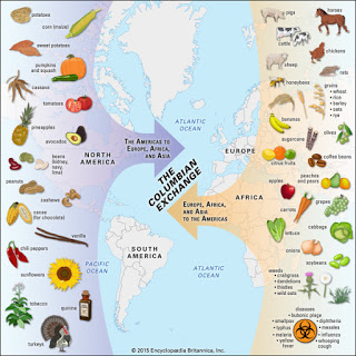
Columbian Exchange Section
The Columbian Exchange activity will assist in introducing the event to you.
Part 1 - Get the modified world map - ( here ) Using Google Slides, copy this map onto 3 separate slides. Make a 4th blank slide for answers to questions.
Get the directions to the activity - ( here )
Part 3 - Columbian Exchange Reading - ( here ) (for Tuesday/Wednesday)
Part 4 - Columbian Exchange DBQ - ( here ) (for Tuesday/Wednesday)
_________________________________________________________________________________________________________________________
Food Origins Assignment
The Food Origins activity will allow students to see the effects of the Columbian exchange on the foods they eat.
Directions for the Food Origins Assignment
For Thursday/Friday in Class will be submitted the first Block Day next week
Assigned questions to each table member. When finished, each student will "teach" the other students about the sections they were assigned, and have them fill-in the document answers. DO NOT SHARE THE DOC AND SIMPLY FILL - IN EACH OTHERS SECTIONS
Read the article and answer the 3 questions at the end.