History of Mapping
Today we are starting the Unit on Latitude and Longitude as well as European Exploration
Introduction to the Unit
We are beginning our Unit on Latitude/Longitude Time zones and the History of Cartography (map making). In this
Objectives-
*Given a blank piece of paper, the student will experience the challenges of a cartographer in producing and accurate map based solely on verbal instructions.
*Given a fictitious land mass to view, students will use only cardinal direction in describing the details to
*Given a description of a fictitious island, students will use recently acquired mapping skills to produce an accurate replication of the described land.
* Given a blank piece of paper students will be able to draw a relatively accurate map of a familiar place they know very well.
Rationale:- Understanding the challenges with making accurate maps will teach the
Evidence:- Students will be able to use an atlas and latitude/longitude coordinates to locate various places

| Does this look very accurate? |
In this activity each student will play the role of a mapmaker (Cartographer) as well as an explorer who visits uncharted lands.
After the Mapping activity, we will go over Latitude and Longitude and Seasons and do a scavenger hunt as well as a Latitude and Longitude Packet - Lat Long Scavenger Hunt
Once the presentation is finished I will post a pdf version of the presentation for students to have.
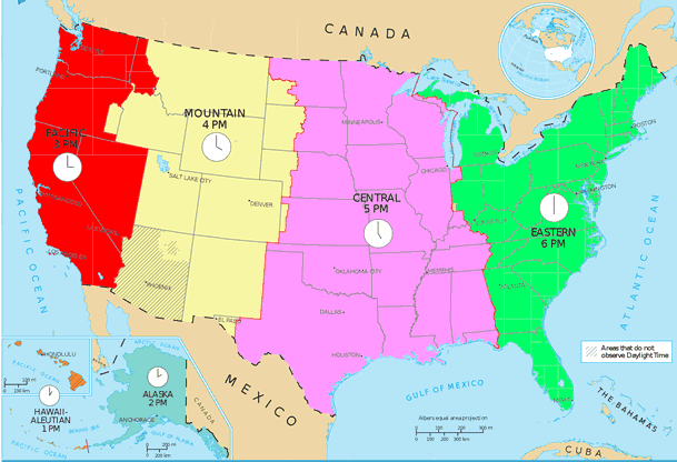
Lastly (if time permits), we will go over time zones and their history, as well as introducing the Early Map Making article which we will summarize/annotate using a google doc with tables.