
________________________________________________________________________________
Latitude and Longitude Section
Objective(s): Presented with a presentation covering the basic elements of Latitude and Longitude, students will be bale to identify various locations around the world based on their latitude and longitude coordinates.
-The student, when requested, will identify at least 10 places on the world map using the given latitude and longitude points to the nearest whole degree with 90% accuracy.
- The student, when requested, will identify the latitude and longitude points of at least 10 places on the world map to the nearest whole degree with 90% accuracy.
Rationale: Understanding how places are positioned and identified on a world map, allows students to better grasp the various characteristics on locations, such as climate, vegetation, animal life etc.
Evidence: Being able to use and understand Latitude and Longitude on a world map, allows students to locate just about anything.
_________________________________________________________________________________


Finish the Lattude and Longitude presentation - ( here )
Timed Quiz/Contest -Latitude/Longitude - ( here )
Use the Activity #4 Map as the answer sheet for all of the activities. Label each activity separately and answer the questions. Act #4 asks you to draw on the map, that is why I copied the map and placed it on a google sheet.
Act #4 Directions - ( here ) Activity #4 Map - ( here ) (use this as your answer sheet for all activities)Measuring Longitude Activity - ( here )
Lat Map Location Calif Activity - ( here )
Lat Map USA Activity - ( here )
________________________________________________________________________________
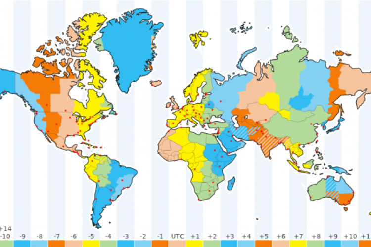
Time Zone Project
Directions - ( here )
Make sure you use a blank piece of printer paper for this assignment________________________________________________________________________________
When the class finishes the Time Zone Project, we will start the History of Mapping Section
________________________________________________________________________________

History of Map Making presentation
Presentation - ( here )
________________________________________________________________________________
EXPLORERS PROJECT
When learning about early Map Making, it should transition into how were those maps used and or expanded into the maps we know today. For that we will study early explorers to understand why they ventured out to "discover" new lands and how maps were shaped by these voyages.
An explorer will be assigned to each student.The Explorer you are assigned is the explorer with the same number as your current seat.
i.e student sitting at seat 11 gets explorer #11
The directions for the project are listed below
This is the world Map you will use on your Explorers project - ( here )
This map is very big, and you should crop out the part of the Map where your Explorer took his voyage(s). Use Google Slides to draw the path(s) from where your Explorer started and where he landed. Be sure to use dates and different colors to depict different voyages (if he in fact took more than one voyage)
Explorers Project - Directions Page: ( Link )
Resources for the Project
Famous Explorers - ( here )Explorers Name and links to informational websites: ( Link )
Explorers Information website:( Link )
All about Explorers:( Link )
Notable Explorers: ( Link )
Conquistadors: ( Link )