
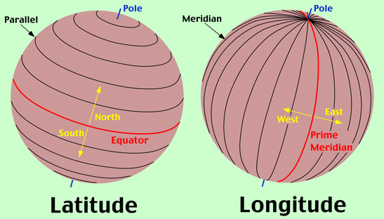
Latitude and Longitude Section
Objective(s): Presented with a presentation covering the basic elements of Latitude and Longitude, students will be bale to identify various locations around the world based on their latitude and longitude coordinates.
-The student, when requested, will identify at least 10 places on the world map using the given latitude and longitude points to the nearest whole degree with 90% accuracy.
- The student, when requested, will identify the latitude and longitude points of at least 10 places on the world map to the nearest whole degree with 90% accuracy.
Rationale: Understanding how places are positioned and identified on a world map, allows students to better grasp the various characteristics on locations, such as climate, vegetation, animal life etc.
Evidence: Being able to use and understand Latitude and Longitude on a world map, allows students to locate just about anything.
_________________________________________________________________________________
Latitude and Longitude presentation -( here )
Latitude and Longitude Review video -( here )
TimeZone vid( here )
Timed Quiz/Contest -Latitude/Longitude - ( here )
Use the Activity #4 Map as the answer sheet for all of the activities. Label each activity separately and answer the questions. Act #4 asks you to draw on the map, that is why I copied the map and placed it on a google sheet.
Act #4 Directions - ( here ) Activity #4 Map - ( here ) (use this as your answer sheet for all activities)
Measuring Longitude Activity - ( here )
Lat Map Location Calif Activity - ( here )
Lat Map USA Activity - ( here )
________________________________________________________________________________